ALGO Traffic
- 4.1
- Rating
- 10.00K
- Installs
- Free
- Price
 Analysis by App-foxy
When I am about to drive through Alabama, I do not always need another general-purpose navigation app telling me where to turn. Sometimes the more useful question comes first: what is happening on the road right now, and should I change my plan before leaving? That is the space where ALGO Traffic makes sense. It is a free Maps & Navigation app from the Alabama Dept of Transportation, built to put ALDOT’s traffic information within easy reach on an Android phone.
My impression is that this is a practical companion rather than a complete replacement for a turn-by-turn navigator. It is most valuable when I already know my destination but want a clearer picture of the journey before committing to it. The app has a 4.1 average from around 54 ratings, with over 10 thousand installs, so it has a modest but visible user base. It is rated for Everyone, costs nothing to use, and its current version is 3.1.5.
That distinction matters. A familiar navigation service may be better at calculating a route, announcing turns, and adapting continuously while I drive. ALGO Traffic is more useful at the decision point before the trip, especially when local road conditions could turn a normal drive into a frustrating one. I found its strongest value in that short routine: check the situation, compare it with my intended route, decide whether to leave, delay, or reroute, and then hand the actual driving over to another tool if necessary.
You May Also Like

 AccuWeather: Weather Radar
AccuWeather Review: A Quick, Clear Forecast for Everyday Decisions
For everyday plans, the best forecast is the one you can understand quickly. AccuWeather makes rain timing, radar, and local conditions easy to act on, with a few trade-offs.

 Hill Climb Racing
Why Hill Climb Racing Still Turns Crashes Into One More Run
A tiny car, a bumpy hill and one more upgrade: Hill Climb Racing keeps resurfacing because its simple chaos makes every near-miss feel personal.

 AliExpress - Shopping App
AliExpress Makes Global Shopping Feel Personal, but Shoppers Bear the Risk
AliExpress turns a global marketplace into a pocket-sized discovery engine. Its reach is useful, its shopping loop compelling, and its trade-offs easy to miss.

 Lords Mobile: Kingdom Wars
Lords Mobile Is a Kingdom-Building Routine, Not a Quick Match
A case-by-case verdict on the building, battles, device demands, and social commitments that make Lords Mobile rewarding for some players and exhausting for others.

 PDF Scanner app - TapScanner
TapScanner Makes Paperwork Easier to Capture, Check, and Share
TapScanner makes scanning with a phone feel less like a rescue operation and more like a dependable step in getting work done. Its capture tools are useful, though not flawless.

 Block Blast!
 Shows How Much a Puzzle Game Can Leave Out
A quiet grid game shows why puzzle players increasingly value instant clarity, repeatable skill and low-pressure play—and where the genre still needs to catch up.
More From Our News Desk
View All News


From a planned trip to a better-informed departure
I find the most useful way to judge ALGO Traffic is not to expect it to replace a full navigation app, but to ask whether it helps me make a smarter departure decision. In this section, I focus on how a quick look at Alabama road conditions can fit into an ordinary routine and help me decide when to leave or reconsider my usual route.
Starting with the road, not the destination
The first useful change in my workflow is psychological. With a standard navigation app, I usually enter a destination immediately and accept the suggested route. With ALGO Traffic, I begin by looking at the wider road picture. That is a better approach when I am commuting, heading toward a busy corridor, or deciding whether a trip is sensible at a particular moment.
Instead of treating the phone as a voice that will rescue me from every mistake, I use the app as a quick traffic-information check. I open it before leaving, inspect the roads relevant to my journey, and then decide whether the route I had in mind still looks reasonable. This is especially helpful for people who drive familiar roads and do not need basic directions repeated every day.
The app’s connection to the Alabama Dept of Transportation is important here. Its purpose is not simply to provide another generic map view; it gives the experience a distinctly local focus. For an Alabama driver, that can make the app more relevant than a broad international navigation service whose traffic presentation is designed for everywhere at once.
I also appreciate the low barrier to trying it. The app is free and supports devices running Android 8.0 or later, which makes it accessible to many people using older phones. Its Everyone age rating also fits the straightforward nature of the tool. There is no complicated learning curve in deciding to check a traffic app before a drive.
The step-by-step check before leaving
My practical routine starts with the intended route in mind, even if I do not build that route inside this app. I think about the main roads I expect to use, open ALGO Traffic, and examine the traffic information around those corridors. The point is not to stare at the whole state map without a question. The point is to look for information that could change my next decision.
I then compare what I see with the assumptions behind my plan. If the main road looks normal, I can leave with more confidence. If the traffic picture suggests a problem, I consider whether an alternate road is genuinely useful or merely moves the delay elsewhere. This is where the app becomes more than a passive map: it gives me a reason to pause before the usual route becomes the only route.
A useful habit is to check twice when timing matters. I can look before getting ready, then check again shortly before departure. Traffic conditions are not a permanent verdict on a road, so a single glance should not become an unquestioned prediction for the entire trip. The app works best as a current snapshot that informs a decision, not as a promise that conditions will remain unchanged.
For a morning commute, I would use it this way: first inspect the main corridor, then look at the roads that could serve as alternatives, and finally choose whether to leave normally or give myself more time. That workflow is more realistic than expecting one app to provide perfect local awareness, route planning, and hands-free guidance all at once.
Reading information without overreacting
Traffic information can create its own kind of friction. A colored road or visible slowdown may look alarming, but it does not automatically tell me whether changing routes will save time. I try to treat the display as evidence rather than an instruction. The best decision depends on the importance of my trip, how flexible my arrival time is, and whether I know the surrounding roads well enough to make a sensible change.
This is one of the app’s less obvious strengths: it encourages a more deliberate driving decision. A general navigation app may quietly recalculate and send me down an unfamiliar road. Here, I remain responsible for interpreting the local traffic picture. That is useful for an experienced driver who knows Alabama’s roads, but it may feel less convenient for someone who wants the phone to make every choice.
I would also avoid making a last-second inspection while already moving. The app is much better suited to a stationary pre-trip check. That is not a criticism of its traffic purpose; it is simply the safer way to use any map-based information. I can make the decision at home or in a parked car, then put the phone away or switch to a navigation tool for the drive itself.
Where the handoffs happen
The most important handoff is between traffic awareness and navigation. ALGO Traffic can help me decide which roads deserve attention, but my usual navigation app may still be the better place to enter the final destination and receive turn-by-turn instructions. I see this as a normal two-app workflow rather than a failure. One tool answers, “What is happening on the roads?” while the other answers, “How do I get there?”
The handoff works best when I make the decision before starting the vehicle. I check the traffic situation, choose the route or departure plan, and then transfer that decision mentally to my navigation app. If I change roads, I enter the revised destination or route there. This takes a little more effort than relying on one all-purpose service, but it also lets me use each tool for the job it handles best.
There is another handoff between official information and personal knowledge. ALDOT can provide a useful traffic view, but I still know things the screen may not express well: which side streets are awkward, where parking becomes difficult, which route feels safer in poor visibility, or which detour is impractical for my vehicle. The app informs my judgment; it does not replace it.
For a family trip, I might make the check while another person handles navigation. For a solo trip, I would complete the planning before pulling away. For a delivery or service job, I could use the app as a quick corridor check between appointments, then return to the navigation app for the next address. These handoffs make the app more useful in real life than simply opening it without a purpose.
One trade-off is that this process can feel fragmented. I may need to move between apps, remember what I saw, and make my own comparison. Someone who wants a single interface with automatic rerouting may find that inconvenient. In my experience, the extra step is worthwhile when the local traffic view is the information I am missing, but not for every short drive.
What the result looks like in everyday use
The result is not necessarily a dramatically different route. Often, the benefit is smaller and more practical: I leave earlier, avoid an obvious trouble spot, or stop assuming that my normal road is the only sensible option. That kind of outcome is easy to overlook because it feels like nothing happened. Yet avoiding an unnecessary delay before it starts is exactly why a traffic-checking app can earn a place on a phone.
Imagine that I need to cross a busy part of Alabama for an appointment with a fixed arrival time. I already know the destination and could ask a navigation app for directions. Before doing that, I use ALGO Traffic to inspect the main road and nearby corridors. If the traffic picture looks concerning, I do not blindly follow my habitual plan. I compare the alternatives, allow extra time, or decide that leaving later would be risky. Then I use my preferred navigation tool to handle the actual trip.
That workflow gives me control at the moment when it matters. It also reduces the chance that I will discover a problem only after entering the busiest section of the journey. The app does not need to dominate the entire drive to be useful; it only needs to improve the quality of the decision I make before departure.
For regular commuters, the value can become a habit. A quick check before leaving may help identify days when the normal routine deserves adjustment. For occasional visitors, the local focus can provide context that a general map does not present as clearly. For parents driving across town, it can help with timing decisions before children are in the car and the trip becomes harder to change.
I would recommend keeping expectations realistic. A traffic display is not a guarantee of a clear arrival, and it cannot remove congestion from the road. Its success is better measured by whether it helps me make a more informed choice. If I use it expecting perfect prediction or full navigation, I will probably judge it unfairly.
The points where the workflow breaks
The biggest weakness is the boundary between information and action. After I inspect traffic, I may still need another application for destination search, detailed route planning, spoken directions, and active rerouting. That extra handoff is manageable, but it is less convenient than an all-in-one navigation service. Drivers who rarely need local traffic context may prefer to stay inside the app they already use.
The second limitation is that the quality of my decision depends on how well I interpret the road picture. If I do not know Alabama’s alternate roads, I may see a problem without having a good solution. The app can make me aware of a delay, but awareness alone does not tell me whether a side route is faster, simpler, or suitable for my trip. This is why I see it as a companion for planning rather than an automatic traffic referee.
There is also a practical risk in checking too often during a journey. If I keep reaching for the phone whenever conditions change, the tool becomes a distraction instead of a safety aid. My preferred workflow is to make the decision while parked, use a separate navigation setup if needed, and only reconsider the plan when I can do so safely.
People outside Alabama should think carefully about fit before installing it. The app’s identity is tied to Alabama transportation information, so its appeal is strongest for Alabama residents, commuters, visitors, and anyone planning travel through the state. A driver looking for broad national coverage or international trip planning will likely get more value from a general map platform.
Finally, the modest review volume means I would not choose it solely because of its store score. The 4.1 average is encouraging, but the more important question is whether its local traffic role matches my routine. I would install it because I want ALDOT-focused road information, not because I expect it to replace every other driving app on my phone.
Who should use it and who should skip it
I think ALGO Traffic is a good fit for Alabama drivers who already have a navigation app but want a dedicated pre-trip traffic check. It is particularly sensible for commuters, people with time-sensitive appointments, families planning longer drives, and visitors who want a local road-information source before setting off.
It is also a reasonable choice for someone who prefers making route decisions personally. The app supports a workflow in which I inspect the situation, weigh the alternatives, and then choose the next step. That is different from handing the entire trip to an algorithm, and some drivers will appreciate the transparency.
I would skip it if I only want spoken directions from one app, automatic rerouting, or a worldwide travel tool. I would also skip it if I never drive in Alabama or if I am unwilling to use a separate navigation service after checking traffic. In those cases, the extra app may add clutter without improving the journey.
My final view is positive but specific: this is a focused, free traffic companion from the Alabama Dept of Transportation, not a universal replacement for Google Maps, Apple Maps, or another full navigation service. Its best contribution happens before the wheels move. I check the road, question my first plan, make a deliberate choice, and then hand the trip to the tool that can guide me. If you drive in Alabama and want official local traffic context before leaving, ALGO Traffic is worth keeping available.
The app was released on February 26, 2025, and its version 3.1.5 experience feels aimed at a straightforward purpose rather than unnecessary complexity. I would recommend trying it during a few normal commutes instead of judging it from one trip. If that brief pre-departure check helps me avoid even one poorly timed departure or rethink one congested corridor, it has done the job I need from it.
FAQs for ALGO Traffic
01What is ALGO Traffic, and what does it do?
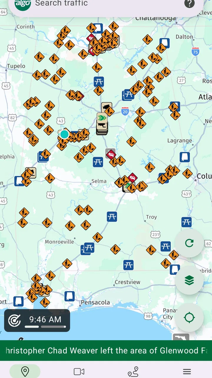
ALGO Traffic is a traffic-information app designed to help drivers check current road conditions before and during a journey. It typically provides access to traffic cameras, congestion updates, incidents, construction areas, weather-related disruptions, and other transportation information. The exact features and coverage can vary by region, so users should confirm that their local roads and highways are supported before downloading it.
02Which locations and roads are covered by ALGO Traffic?
ALGO Traffic primarily focuses on transportation information for Alabama, making it most useful for drivers traveling on the state’s interstates, highways, and major roads. Coverage may include traffic cameras, crash reports, lane closures, roadwork, and travel alerts, although availability can differ between locations. If you regularly travel outside Alabama, you may need another traffic service for broader geographic coverage.
03Does ALGO Traffic provide real-time traffic updates?
The app is intended to provide current transportation information, but not every item should be interpreted as an instant, second-by-second update. Camera images may refresh periodically, while incident reports, construction notices, and road closures depend on information received from transportation authorities. For safety, check conditions before driving and never interact with the app while your vehicle is moving.
04Does ALGO Traffic offer navigation or turn-by-turn directions?
ALGO Traffic is mainly a traffic-monitoring and travel-information tool rather than a complete navigation application. It can help you understand congestion, view cameras, and identify incidents or closures, but it may not provide the same route planning, voice guidance, or automatic rerouting features found in dedicated navigation apps. Many drivers use it alongside a navigation service to make better travel decisions.
05Is ALGO Traffic free, and does it require location or internet access?
ALGO Traffic is generally available as a free public-service application, although users should check the current store listing for any changes. An internet or mobile-data connection is normally required to load traffic maps, camera images, and updated alerts. Location permission may improve convenience by showing nearby information, but users can review the requested permissions and disable optional access through their device settings.
Pros
- Provides real-time traffic updates for smarter route planning.
- Helps identify congestion and potential delays before you travel.
- Useful for daily commuters and frequent drivers.
- Can support faster decisions when choosing alternative routes.
- Simple traffic-focused design makes key information easy to find.
Cons
- Accuracy may vary depending on location and available traffic data.
- Some features may require an active internet connection.
- Traffic information can be delayed during major incidents.
- Coverage may be limited in smaller towns or less-traveled areas.
- Frequent location use can increase battery consumption.

ALGO Traffic
Gallery